Weekend weather: Humidity sticks around
Map courtesy nhc.noaa.gov
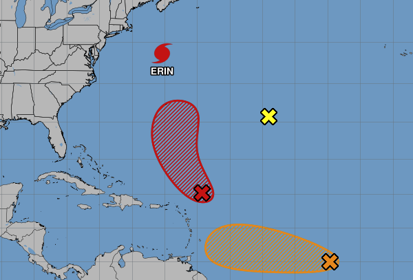
Aug. 22. Off shore hurricanes and tropical storms tend to grab the summer humidity and pull it northward in the days after the storms pass through but it looks like we won’t see much benefit from Hurricane Erin this weekend, which never got any closer than a few hundred miles offshore. The next tropical system is located a few hundred miles east-northeast of the northern Leeward Islands and is currently a broad area of disorganized showers and thunderstorms, and forecasters predict that a tropical depression is likely to form this weekend.
Friday: A chance of showers before 11am, then a slight chance of showers and thunderstorms after 3pm. Mostly cloudy, with a high near 80. East wind around 5 mph. Chance of precipitation is 30%. Tonight expect patchy fog. Mostly cloudy with a low around 68. Calm wind.
Saturday: 20 percent chance of showers and thunderstorms after 2pm. Patchy morning fog. Otherwise, mostly cloudy, with a high near 82. Saturday night slight chance of showers and thunderstorms. Mostly cloudy, with a low around 67. Calm wind. Chance of precipitation is 20%.
Sunday: Slight chance of showers, then a chance of afternoon showers and thunderstorms. Partly sunny, with a high near 84. Calm wind. Chance of precipitation is 40%. Sunday night 30 percent chance of showers and thunderstorms before 8pm. Mostly cloudy, with a low around 67.
Next week: Highs in the 80s and cool summer nights return.
The weather is brought to us from the National Weather Service.
Our Partners